As the escalating effects of global climate change become more pronounced, the need for monitoring and understanding extreme weather events has never been more critical. Enter ICEYE, a Finnish Earth observation company that stands as the world’s first global and continuous data utility.
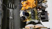
ICEYE is at the forefront of climate change solutions with its unique synthetic-aperture radar (SAR) satellite technology. SAR technology, which involves creating high-resolution images or three-dimensional reconstructions of objects like landscapes, is a pivotal tool in ICEYE's mission. ICEYE currently owns and operates the world’s largest constellation of SAR satellites. ICEYE's technology is a practical tool used by various customers in sectors such as insurance, natural catastrophe response and recovery, security, maritime monitoring, and finance. Governments and large multinational corporations can purchase radar imaging satellites from ICEYE and operate them independently or arrange for ICEYE to manage the spacecraft exclusively on their behalf. All these sectors require reliable, repeatable, precision data that can’t be hidden, and ICEYE's technology delivers just that.
ICEYE stipulates that the world currently faces three key problems around Earth Observation Data: reliability, timeliness, and access. The ICEYE radar satellite constellation addresses these challenges directly in the following ways.
ICEYE's SAR satellites can capture high-resolution images of the Earth's surface, regardless of weather conditions or light, allowing for continuous monitoring of various environmental changes. These images can be used to track deforestation, land use changes, ice melting, and other climate-related phenomena. This is highly valuable for climate research as it enables an unprecedented understanding of climate patterns, changes in ice cover, sea-level rise, and other critical climate-related factors. This further helps to improve climate models and predictions. In the US, for example, the intensity and frequency of wildfires have increased significantly. In 2020, the wildfire season burned 10.2 million acres of land, costing the economy $19 billion, of which $16.5 billion was property damages[1]. The events showcased the intricate challenges that insurers and disaster response teams encounter when dealing with wildfires of such magnitude. Particularly when assessing damage caused by heavy smoke and ash and restricting access to those affected.
ICEYE’s SAR technology is not just about data collection; it's about action. It enables more effective disaster management and response by providing rapid and accurate mapping of areas affected by natural disasters such as wildfires, hurricanes, earthquakes, and floods. This technology minimises the impact on affected communities and the environment by significantly improving disaster response and recovery efforts. In a data-driven era, insurers are always looking for innovative information to streamline their claims procedures, aiming to reduce claim expenses while delivering top-notch service to policyholders. In this context, radar remote sensing data is a game-changing tool for managing catastrophic events.
Furthermore, ICEYE's SAR satellites can assist in assessing the progress of sustainable development projects, such as those related to renewable energy, forestry, and urban planning. By monitoring these project's effectiveness, decision-makers can make data-driven decisions to further sustainable initiatives. To this end, ICEYE has already assisted Ukraine's global security efforts. ICEYE signed a deal with the Serhiy Prytula Charity Foundation[2] to use ICEYE’s satellite constellation to provide objective data and technological support to Ukraine[3]. This agreement has significantly aided the government of Ukraine’s urgent request for critical Earth Observation data and greatly benefited their armed forces.
Additionally, this data can be used to combat illegal activities that adversely affect the environment, such as illegal deforestation, mining, and fishing. By providing reliable and frequent monitoring, efforts to enforce environmental regulations and protect vulnerable ecosystems are supported.
With ICEYE’s monitoring capabilities, insurers and governments can stay on top of increasing economic and insured losses as these monitoring solutions provide near real-time hazard and damage data across the globe. If we take oil spills as an example, 150,000 tons of crude oil is unintentionally deposited into our oceans every year[4]. These events have disastrous environmental and economic implications; identifying where and when they happen is significantly difficult, yet necessary. Doing so requires persistent monitoring, which is only possible from space.
Companies like ICEYE are just at the beginning of what is possible. They are a shining example of how space can help our climate action and sustainable development. Investment in SpaceTech companies like ICEYE and the growth of the new space economy are new frontiers for solving humanity's most significant challenges. Reaching net zero is seemingly impossible without space. Thus, utilising the technology and data analysis from space, delivered by companies like ICEYE, reduces waste and enables regeneration. ICEYE’s ability to monitor any location persistently and flexibly is a game-changer, providing insight and response capabilities that have never been seen before.
[1] KourKouli, P (2023). Revolutionising wildfire monitoring with ICEYE’s SAR Technology, ICEYE, 12 May. Available at: https://www.iceye.com/blog/wildfire-monitoring-with-sar (Accessed: 28/07/23)
[2] Serhiy Prytula Charity Foundationhttps://prytulafoundation.org/en
[3] Wall, M (2022). Ukrainian charity buys radar satellite services to help fight Russian invasion, SPACE.com, 19 August. Available at: https://www.space.com/ukraine-radar-satellite-services-russian-invasion
[4] Gomez, N (2023). See and Respond to oil spills as and when they happen, ICEYE, 27 April. Available at: https://www.iceye.com/blog/see-and-respond-to-oil-spills-as-they-happen-with-sar (Accessed: 28/07/23)
 unknownx500